...they would be "poked" or punted with long poles
called "quants" or "spreads," from Cattawade to Mistley
As far as we know, the River Stour was always navigable. This is certainly true of the other Essex Rivers, such as the Lee and the Roding, so is likely to be true of the Stour. However, the direct archaeological evidence for it is only slight. We have to make guesses from the evidence that is available. It is certainly likely that the considerable amount of stone required for building the Castle, Priory, and church in Clare was transported by river, as probably was Sudbury's stone. This is because a horse could carry up to half a ton of goods on its back, could pull a ton in a wagon on the roads that were available, but a single horse could pull between thirty and fifty tons by river.
When the Romans conquered northern Europe they found a culture that was, in certain respects, more technically advanced than themselves. The Celts, in particular, were highly skilled as coopers, wheelwrights and boat builders. The major rivers of Europe were all intensively used for navigation and had been since the Bronze Age. The Celts had developed the wooden barrel as a transport device. It could be rolled easily, and could be rolled on and off specially constructed river-craft called punts. It was far quicker to load or unload a shipment of barrels from a punt than a shipment of amphora from a Roman craft. At that time, the imports were of wine and salt fish. There were a vast numbers of oysters eaten, and it is very likely that these were shipped up the river too.
We are forced to speculate about the use of the East Anglian rivers in prehistory. We can be sure that the area near Chelmsford was a major port, since the name 'Magus' suggests a pre-existing trading centre, connected with the sea. An unusually large number of amphoras have been found in the area. The Stour was heavily settled, and the placement of the roman towns in the Stour Valley suggests that the river was an important means of transport then. The Stour, which was very different in its characteristics to the artificial channel we see today, was probably navigable as far as Clare. In the estuary, barges were probably used, but navigating the upper river involved using punts, flat-bottomed boats with a very shallow draft. In Roman times, it would seem that Samian Ware, Wine, tiles and stone were probably the chief imports to come by river. Several of the villages in the Stour show signs in their layout, of having been trading centres for river-borne goods. Typically, this involves a main street parallel to the river with plots stretching from the street to the river down a fairly steep slope.
Until the expansion of milling in the Middle Ages that came about with the invention of the vertical mill-wheel, the obstructions on the river were fairly slight. When mills used horizontal wheels, they took little water, and the leats were therefore only small side channels. The weirs were simple makeshift structures that could be dismantled in sections, called paddles, to let boats through. In East Anglia, they were known as 'staunches'. It became the practice for boats to be grouped together for travel and the downstream journey was made more rapid by the coordinated release of the water through the staunches. Boats often carried their own materials for making ad-hoc staunches where the river was too shallow. Where the going became too difficult, it was not unusual for boats to be slid along wooden ramps bodily, though there is no evidence of this being necessary on the Stour.
However, by the sixteenth century, the traditional river transport had become increasingly difficult due to the unrestricted dams and weirs, and leats that were required by the big two, and four-stone mills then being constructed. The mills were re-engineered to provide more capacity, and this required more water flow and a greater 'head' or height of water. The Weirs got bigger and the head-races got deeper and longer. Also the common land in the valleys was becoming increasingly fenced in to the point that it was no longer possible to provide a towpath along the river.
By the seventeenth century, the river was impossible to navigate, though small sections were probably still used for transport of hay, reeds and grain. The millers had increased the head of water too much. The only way forward was the creation of pound locks. There were several initiatives to sort matters out, so it must have been causing difficulties. Not least of these difficulties was the increasing use of Coal, or 'Seacole' as it was termed from its transport by costal barge. In 1638, Arnold Spencer, who had created staunches on the Great Ouse to improve the Navigation there, turned his attentions to the Stour, receiving rights on the Stour in return. In 1658, a Mr. Raymond offered, on certain conditions, to make the River Stour navigable down to Manningtree. He was to obtain the consent of the owners of land adjoining the river. This ambitious scheme fell through because of lack of funds.
An Act of Parliament was passed in 1705 to make the river navigable from Sudbury to Brantham, by the building of thirteen pound locks, or 'stanks', in the East Anglian dialect, and two flashlocks. These were at Great Cornard, Henny, Pitmore, Bures, Wormingford, "The Swan" Wiston, Nayland, Horkesley, Boxted, Langham, Stratford, Dedham, Flatford and Brantham. There were twelve toll stages, The river was twenty three and a half miles from the quay to Brantham lock, and twenty six miles in all, measured to Mistley Quay. The presence of flashlocks was strange, if all were built at the one time, and suggests that the flashlocks were part of an already-existing navigation over at least a section of the Stour.
The preamble of the Act sets out:
"Whereas the cleaning and effecting of a passage for barges, boats and other vessels by the River Stower from the town of Manningtree in the County of Essex to the town of Sudbury in the County of Suffolk, will be very beneficial to trade, advantageous to the Poor and convenient for the conveyance of coals and other goods and merchandizes to and from the said Towns and Parts adjacent, and will very much tend to the Employing and Encrease of Watermen and Seamen and as a means to preserve the Highways in the near and said Counties and Towns: Be it therefore enacted . . . that the Mayor and Aldermen of Sudbury shall be authorised and empowered, at their proper costs and charges, to make the said River of Stower Navigable, Portable, and Passable for Barges, Boats, Keels, Lighters, and other Vessels."
One hundred "proprietors" or 'Undertakers' were appointed to supervise and fund the operation. Work was started in July 1708, and was completed ahead of schedule, in 1713. The Quay, and Quay lane were in place in the 1714 map of the town, so it seems that the 'Navigation' was finished by then. So there then commenced around two hundred years of successful navigation.
In 1760 another Act appointed one hundred new commissioners, the names including John, Thomas and Edward Burkitt of Sudbury, Samuel and John Gainsborough, and a host of other names still associated with the area.
The river trade must certainly have flourished during the 18th century, for in 1817 there were thirty-six barges on the river, including three belonging to Messrs Constable of Dedham, and six owned by Mr. Elliston Allen, of Sudbury. Apparently four years later there was an increase in traffic for forty-one barges were working.
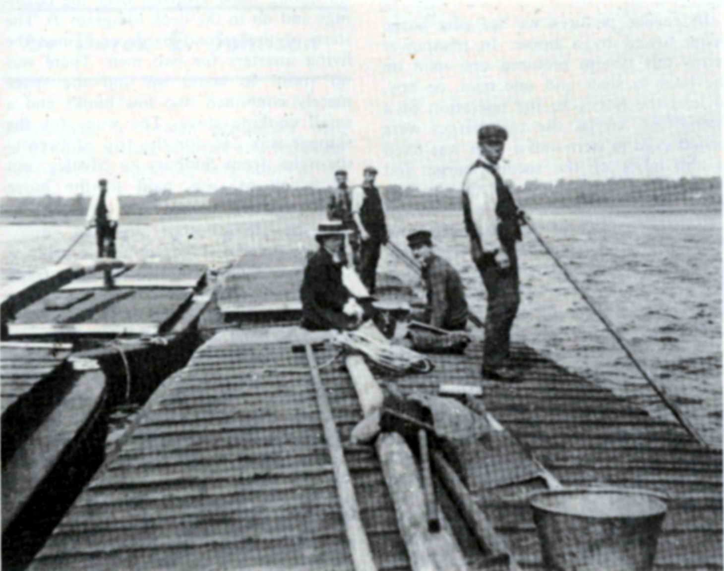
The downstream journey took around two days, depending on the tide at Brantham. The barges were originally 27 ft long and 9 ft wide, and carried 26 tons. In the early days, they worked singly, but later on worked in pairs. Originally, a horse towed a single barge. In manpower terms this system required one man on the boat to steer and one man, or boy, to lead the horse. In the open tidal stretch of water from Brantham to Mistley, a small square sail was used if the wind allowed it, and this practice is illustrated in some of counstable's pictures. Otherwise, the barges would have to wait for the ebb tide, whereupon they would be "poked" or punted with long poles called "quants" or "spreads," from Cattawade to Mistley
Although the barges seemed quite large in the river, they were only a sixth of the size of a Thames Barge, which was used for the final leg of the journey from Mistley to London. Constable, in his picture "Boat Building near Flatford" c. 1815, shows a clinker built barge being built, probably in oak, about forty feet in length, a continuous hold, with a small space near the stem. In the background can be seen a single barge being towed along the river. Over times, bigger and bigger barges were built until they became 47 ft. long by 10 ft. 9 in. wide, drawing 2 ft. 9 in. when loaded with twenty-six tons.
In due course, at around the beginning of the nineteenth century, it became apparent that a single horse could tow two barges, so the characteristic 'Stour Gang' was invented, where two barges were attached together. Constable's picture "View on the Stour with Flatford Old Bridge" c. 1827. shows an early version of the system. This unique system was still in use when the navigation ceased. To make up a 'Stour Gang', two barges were lashed stem to stern. A tiller was then fixed to the bows of the second barge and extended to the middle of the leading barge. A small hole was left in the hatchway in the middle of the first barge and the skipper stood in this recess to steer the two, using the second barge as a rudder while the horse was towing the pair along the river. It made for a very maneuverable load around the twisty parts of the river. The stern of the second barge contained the cramped living quarters for two men. There was no room to stand up and the space merely contained two low bunks and a small cooking stove. In Nayland, there was a hostel for the overnight stop, and the local pub had a good trade from the Navigation.
The biggest problem faced by the navigation was the fact that the landowners were very wary of the scheme and, in many cases, refused to allow a towpath to be made. This meant that the towpath kept changing banks of the river, and the horses had to be trained to leap onto the barges to be transported to the other bank. The leading boat contained a small platform at the bows to enable the towing horse to be ferried across the river when the tow path crossed from one side to the other. This occurred thirty-three times on the trip from Sudbury to Brantham. At Bures, the towpath changed side six times. The horses were, of course, specially trained.
From the start, there was a good trade downriver in Beans, wheat, barley, Malt, and woollen goods, which were then transferred to larger vessels, usually Thames barges, at Mistley and Manningtree. depending on the state of the tide at Brantham. To this cargo was added flour from the various mills on the route, which prospered greatly by the trade. Increasingly, bricks from Cornard and Ballingdon, and both chalk and lime from Cornard was shipped by barge. There was once a light railway from the brickworks to a quay for loading the bricks. For the return journey to Sudbury the barges carried large quantities of coal, which had been shipped to Mistley from the north, woad for the woollen industry, oil, glass, tallow, paper, as well as quantities of iron and lead.
In 1842, the river between Sudbury and Clare was surveyed with the intention of extending the navigation to Clare, but the cost proved to be too high.By the middle of the 19th century the river trade had reached its zenith, and between sixty and seventy thousand tons per annum were being transported up and down the Stour.
When the railway arrived in 1849, there was talk of the two concerns amalgamating, but negotiations fell through and the Stour Navigation determined to continue in competition with the railway. At the time, it was able to transport bricks and produce via the Thames in large quantities right into the heart of London. and close to the edge of London near the river where development was then taking place, and it felt confident that it could compete. This it managed to do successfully for a long while, by lowering the tolls dramatically, and because of the awkwardness of loading and unloading railway goods wagons, but the opening of the Bishopsgate goods yard in London, and the extension of the suburban services all over london eventually swung the battle in favour of the railway, as it meant that the heavy goods such as brick that Sudbury manufactured could be delivered directly to their destination via the suburban rail network.
The main cargoes down the river to Mistley were chalk, bricks from Allen & Boggis at Sudbury, and flour from Clovers at Dedham and Bakers at Gt. Cornard. The flour cargoes were always brought to the Great Eastern Railways shed near the lower dock at Mistley Quay, now filled in. Here a unique but effective device was used to unload the barges. A horse was coupled to a simple system of ropes and pulleys which hung out over the hold, and by walking backwards and forwards all day long without any attention except the regular word of command, the 2 cwt. bags of flour were unloaded quite quickly.
The brick cargoes were usually loaded into Thames barges destined for London, since there was a great demand for the white Sudbury bricks, termed 'Suffolk Gaults'. These brick were used in facades in London because of their high quality, and resistance to frost and damp. The 'Suffolk Reds' also attracted a premium price in London that more than paid for the extra effort of shipping them. Transshipment of these heavy cargoes was done by hand, the bundles being thrown from hold to deck, deck to deck, and then down into the hold of the sailing barge. Because it usually took five or six river barges to load a Thames barge, it was quite common for a small convoy of barges to come down the river.
For the return journey the barges carried large quantities of coal for Sudbury gasworks, which was set conveniently near the river. This coal was shot straight into the holds from the railway trucks. Seed corn from Brooks, as well as quantities of maize, stone, tallow, soda and oilcake all found their way up river in the barges.
Because of the frequent changes in the side of the river that the towpath was on, and the poor state of its upkeep, there was a great deal of interest in the idea of using a steam tug for navigation. This was finally tried out after some false starts, in January 1865. The trial was not a success and in December 1867 it was put up for sale. In 1873, it was finally sold. Remarkably, parts of the propellor and shaft survive, and it would seem that the steam tug was converted for use as an ordinary barge, for the mechanical parts turned up in an old barge a hundred years later. The purchase of a steam dredger in 1879 was more successful, for it lasted until 1908, by which time its boiler would probably have been worn out.
In 1890 the River Stour Navigation Company's fortunes had reached a low ebb, and a financial loss for that year contrasted vividly with the average yearly profit of over £400 in 1848.
In 1892 the company was incorporated under the Companies" Act and in the following year new Articles were adopted and a capital created for it of £6,000. Although trade continued to dwindle, there was about twenty-six barges still working on the river at this time, and the tonnage carried had dropped to about 20,000 per annum.
In 1913 the company sought liquidation, but the following year efforts were made to revive trade. The last barge to pass through Boxted lock was in 1916 and that year many of the barges were scuttled near the chalk pits in Sudbury, evidently on the orders of the Admiralty! The lower stretches of the river continued to be worked and the last cargo from Dedham was in 1930. In 1928, the locks at Brantham, Flatford. Stratford St. Mary and Dedham were renovated at great expense. All this proved of no avail for rail and road transport had by this time killed the economic viability of river transport.
The River trade came to an end in 1930, after 225 years of faithful service to the area.